Field names and old names in the Dietkirchen district
Nowadays, when there are hardly any farmers left in the villages, the knowledge of the field names, especially the old field, district and parish names, has almost been lost, mainly due to the absence of farmers.
Many of the old names were known to everyone in the village in the past and defined the individual areas in the fields and nature quite clearly, without having to have maps in hand that would have clearly marked these properties.
The origins of these names are almost unknown today, but many of the names probably date back to Frankish or Celtic times.
Some field names still exist today. Since acres often have their own old names, it is often possible to confuse acres and fields.
The following overview map shows the still known field names in Dietkirchen.
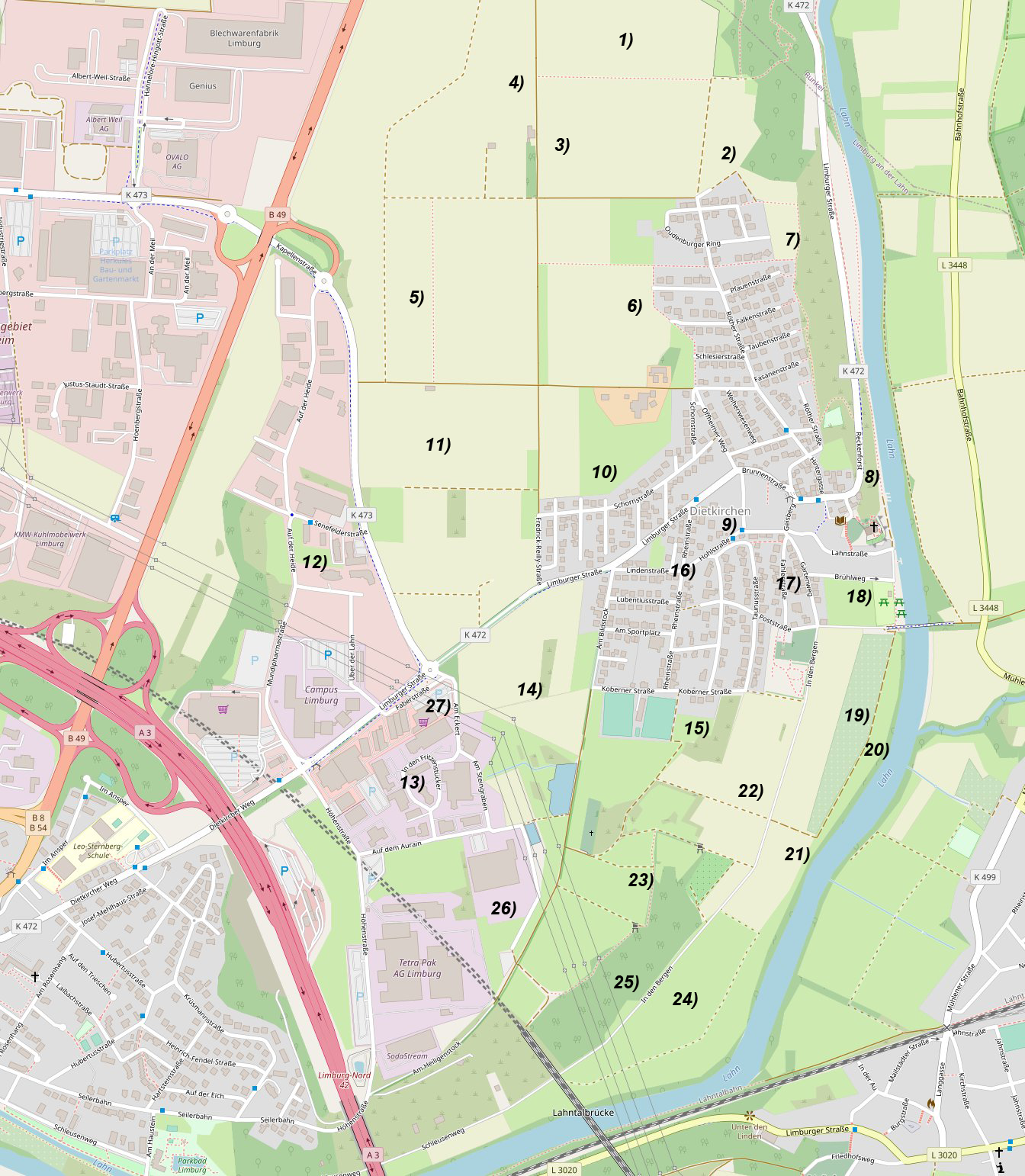
Explanation of the individual numbers:
# Name
1 Am Hain
2 Im alten Graben
3 Aufm Tanzplatz
4 Im Johannsstück
5 Im Fuchsen
6 Im Weiherstück
7 Auf der Röth
8 In der Höhl
9 Auf der Hohl
10 Am Bildstock
11 Am Heidenpfad
12 Auf der Heide
13 In den Fritzenstückern
14 Am Strichweg
15 Am Kissel
16 An der Rheinstrasse
17 Im Fahler
18 Im Brühl
19 In den Gärten
20 Am Badeplatz
21 In den Mühlenstücker
22 In der Au
23 Am Steingraben
24 In der Feldwies
25 In den Bergen
26 In der Vogelseck
27 Am Eckert
In the following, the individual names are listed and an attempt is made to explain them as far as possible. In addition to these field names that still exist today, the Hesse State Historical Information System lists other field names for Dietkirchen, which are described later below.
A great help in explaining the names were notes for a concept for a school essay by Heribert Brötz, probably from the 1950s, which was made available to the author of this page via the village head Markus Wirth in 2021. Brötz’s notes are shown in italics.
1 – Am Hain
This parcel is located directly at the grove, dialectally “Am Huu”, which, however, already belongs to the Dehrner district. According to H. Brötz, the parcel “Am Hain” used to form the “Feld am Höhfeld” together with the parcel “Am Tanzplatz”.
2 – Im alten Graben
Brötz writes that the field “Am Alten Graben” is bordered towards the Lahn by a quarry which extends along the Lahn and the road Dehrn / Dietkirchen into the area of Dietkirchen.
However, this quarry has been lying idle for several years and has been renaturalised in the meantime.
A footpath used to lead from Dehrn to Limburg through the “Alter Graben” and the corridors “Am Tanzplatz” and “Im Fuchsen”. In the field “Im Fuchsen” there was an acre called “Am Dehrner Pfad”.
3 – Am Tanzplatz
According to Heribert Brötz’s school essay concept, the field “Am Tanzplatz” got its name from the fact that the Dietkirchen market is said to have taken place at this place for a long time. Unfortunately, there is as yet no well-founded basis for verifying this statement.
4 – Im Johannsstück
The origin of the field name possibly comes from an original owner’s name. H. Brötz writes that sand is found here at a depth of about one metre in the field “Im Johannsstück”. When the Konvikt in Hadamar and the Amtsgericht in Limburg were built, the sand was fetched from this spot, the “Gehannsstück”, in Dietkirchen.
Even after the war, the inhabitants of Dietkirchen continued to fetch the sand there for building.
That is why this place, which borders on the Dehrn district, is also called “Sandkaut”. The soil overlying this sand is good and fertile and is used as meadows and arable land.
5 – Im Fuchsen
The explanations for the name “Im Fuchsen” are very meagre. It is generally assumed that this field is a landscape area where a large number of foxes were once found.
According to H. Brötz, the “Fuchsen” was formerly divided into the field “Im Fuchsen” and the “Feld im großen Ahlen”. “Ahl” or “Oll”, as it is called in dialect, can also mean (except for the explanation in 10 – “Am Heidenpfad”) border.
For example, if two houses stand close together, the space in between is called “Oll”. The name “Feld im großen Ahlen” thus means a large field on the boundary of the district.
6 – Im Weiherstück
H. Brötz writes about this:
The name “Weierstück” can be explained by the fact that large ponds form here when it rains heavily.
The 3rd area is called the “Naßgewann”, because it is always particularly wet there.
The “Weiherstück” is also the site of the old waterworks, which is why the farmers often call it “Umm Bornhäusje”.
The 4th field is called “Umm Wehling”, which in High German means “Am Weg entlang” (“along the path”).
The first field, the “Weiherwies”, was used as cattle pasture until a few years ago. Today it is a building site.
The “Weiherstück” used to be part of the field “Feld an der Zähensohl”. “Sohl” always refers to a somewhat lower-lying area and “zäh” (“tough”) means that the soil is not good to work. The “Feld an der Zähensohl” therefore got its name because it lies somewhat lower and is difficult to work.
7 – Auf der Röth
According to H. Brötz, the field got its name from the colour of its soil:
It is reddish earth, i.e. loamy bog (called “Booles” in dialect from the Latin word bolus), which is unsuitable for arable farming. The entire area consists of a large meadow that serves as cattle pasture and on which there are many fruit trees. Because the only field barn of the village is located here, this field is called “U de Feldscheuer” by the farmers.
A small meadow, which is somewhat separated by an elevation, is called “Bummet or Bummert”. This name comes from the owner of this plot of land. It was the last canon of Dietkirchen. His name was Bourmer and the meadow was called “Bourmers Wies” after him, which in the course of time became “Bummert or Bummet”.
The field “Auf’der Röth” did not have its own field name before the first consolidation, but belonged to the “Feld auf der Hohl”.
8 – In der Höhl
According to Brötz, the steep slope between the road to Dehrn and the river Lahn is marked with the name “In der Höhl” on a map that was probably available to him when the concept was drawn up.
It is said to have come about because there are several caves on this slope. Before the first consolidation, the map name for this area was “In der Hohl”.
It is more likely, however, that the difference between the two names is only due to a change in sound. But no one in Dietkirchen uses either of these names; everyone says “In der Hehl”.
This could also be a phonetic change. But “Hehl” is also a very common name for a slope in our homeland. This slope is often, as in this case, near the cemetery. A grave of the Franks was found here. The Franks liked to lay their graves on hillsides. Only grass and a few shrubs grow in the stony soil. Only at the foot of the limestone rock are there some gardens. In former times they had their own field name, they were called “In den Kappusgärten” (vegetable gardens) . Until two years ago, a section of the slope in the “Hehl” was used as a rubble dump. After this was forbidden, an attempt was made to cultivate a vineyard on this favourably situated slope, which has since been abandoned.
9 – Auf der Hohl
The field possibly got its name from the fact that it describes the area along today’s “Hohlstrasse”. A hollow road is often a tubular and narrow lane. However, a hollow can also indicate deepened places in the terrain: depressions and pits, small ravines and especially hollow roads.
10 – Am Bildstock
The field “Am Bildstock” is located at the end of the village in the direction of Limburg on the right-hand side of the Limburg road. It owes its name to a wayside shrine that stands under a large lime tree at a fork in the road at the entrance from Limburg. The soil is very good here, it is only used as farmland.
11 – Am Heidenpfad
The origin of the name “Am Heidenpfad” cannot be determined exactly. Perhaps it goes back to the time of Lubentius, when this area was populated by pagans. It is also possible that the word “Heide” (heathen) is derived from “Haare” (hair), which means gypsy. It is therefore reasonable to assume that gypsies travelling through the area were given a place to camp here.
The 6th field is called “Kautestück” by the farmers because there used to be deep holes here, which are said to have come from an old war camp. The 7th and 8th fields are called “Oll”. This name is a dialectal term for “Ahl”. The field “Am Heidenpfad” used to be divided into the “Feld am Heidenpfad” and the “Feld im Ahlen”. During the first consolidation in 1872, these two fields were united under one name.
“Ahl” is a word of Gallic origin and means a sheltered place near the village. Often this place was surrounded by dense enclosures to protect livestock against predators and raids.
The “Heidenpfad” lies to the north of the Dietkirchen-Limburg road, its soil is good and was formerly used as pasture, today exclusively as arable land.
12 – Auf der Heide
In dialect, this field is called “Uff de Haad”. The parcel “Auf der Heide” is located north-east of the Dietkirchen-Limburg road. There used to be a small wood here, which was thinned out somewhat because of a high-voltage power line. After the 2nd World War, when there was nothing to burn, it was completely cleared by the inhabitants. The soil is very poor, it is only partly used as farmland. The 7th and 8th Gewann are called “Uff de Haarewies”.
For an explanation of the name, see also “11 – Am Heidenpfad”.
13 – In den Fritzenstückern
Many years ago, the entire parcel “In den Fritzenstückern” belonged to a Mr. Friedrich, who is said to have been a very rich man. Because this parcel lies on the Dietkirchen-Limburg boundary, it is usually called “U de Grenz”. It consists partly of grassland and partly of arable land.
14 – Am Strichweg
Unfortunately, there is no record of Brötz’s naming of the field. However, he does describe the fields that make up the parcel.
The four fields of the “Strichweg” are named “Zu den Vier Morgen”, “Kessler”, “Rauhanse” and “Lang Sohl”.
The name “Kessler” came about because there is a small round indentation, a cauldron, here. “Rauhanse” was probably the derisive name of a former owner, and “Lang Sohl” got its name because the area in question is long and narrow and lies somewhat lower.
I have not been able to find an explanation for the name “Am Strichweg” itself. The soil here is fertile and is used exclusively as farmland.
15 – Am Kissel
An old gravel pit gave the field its name.
The soil is very stony, only the 2nd field is used as arable land. The sports field is located on the first field. The third field is grassland. It is called “Iwwerm Bääg” in dialect because it lies below a small hill.
16 – An der Rheinstrasse
The field name “An der Rheinstraße” can be explained by the fact that an old trade route from Cologne to Frankfurt led through this area. Even today, in years when it is very dry, one can see exactly how the road ran, because the fruit grows less tall than usual at this point.
This road led across the Lahn opposite the village of Mühlen at a ford. (The old Bubenheim road, which led from Bubenheim – today’s Kirberg to Mühlen, was probably a section of this road). This place is called Postmauer in oral tradition, because a post station was established in Dietkirchen in the “Arch” (a). Even the gardens near this house are still called post gardens.
The official name for the “Postmauer” parcel is “Badeplatz” and is dealt with in more detail under a separate item.
a) The “Arch” was formerly the oldest house in Dietkirchen. The name “Arch” was probably derived from the fact that it belonged to the archdeacon of the monastery.
17 – Im Fahler
The parcel “Im Fahler” is the smallest in the district.
The name “Fahler” (from Middle High German: Vahl, vallen, fallen) means mountain slope, lowering, slope. The terrain, on which some gardens are located, slopes steeply in a southerly direction. In the past, the map name for this corridor was simply “Gärten” (“gardens”). People call it “Rimmele” because the soil was so tough when gardens were planted here that after digging, the soil was still so stiff that it often manally needs to be crumbled up (in German dialect “rimmele”).
18 – Im Brühl
“Im Bruil”. “Brühl” derives from the Latin-Celtic word “brogilus” (= enclosed copse). It means marshy, fat, bush-covered cradle terrain and is always close to the village.
Today, however, there is no longer any meadow or bush on this terrain, but it is good arable land.
19 – In den Gärten
Many people have their gardens here who have no space near their house. The location is very convenient because it is very close to the Lahn. If it is too dry in summer, people only need to walk about 30-40 metres across the “bathing place” to get water in the Lahn.
20 – Am Badeplatz
If you walk along the “Leinpfad” under the Lahn rock a little further downstream, you come to the “Badeplatz”. A ford used to lead across the Lahn here, this spot is called the “Postmauer” (for explanation see “An der Rheinstraße”). The ground is only used as a meadow, where there is lively bathing and camping in summer.
The names “Wieslatt” and “Grindchen”, into which the “Badeplatz” is divided, are very old names, but are still used today. They can be explained by the fact that the piece in question is long and narrow and very small respectively.
21 – In den Mühlenstückern
Even further down the Lahn are the fields “In den Mühlenstückern” and “In der Feldwies”. The “Mühlenstücker” are very fertile farmland. They owe their name to their location opposite the village of Mühlen, which lies on the other side of the Lahn.
22 – In der Au
“In der Au” is the best farmland in Dietkirchen. “Au” always means favourably situated and fertile farmland. “Feld in der Au” was the name of this area before the 1st consolidation.
23 – Am Steingraben
The “Steingraben” (“Staagroowe”) adjoins the “Kissel” in a westerly direction. The soil here is not particularly stony, as one might expect, but the name comes from a single large boulder protruding from the earth at the edge of a deep ditch. The 3rd area in which this V-shaped ditch is located is called “Lay”. The walls of this ditch can be compared to the sides of a roof, and since roofers used to be called “Laydecker” (and Laadecker), the origin of the name can be explained in this context. On the 5th Gewann there is a graveyard of fallen soldiers from the First World War.
24 – In der Feldwies
The name “In der Feldwies” is very easy to explain: It is a large meadow enclosed only by fields except for the Lahn. The soil is marshy and therefore only suitable as a meadow.
25 – In den Bergen
An explanation for “In den Bergen” is already given in the name itself. It is hilly terrain consisting mainly of meadow with some bushes. Only the first Gewann is used as arable land. It is called “Burgum” (Burg-um = what lies around the mountain or at the foot of the mountain.). Recently, plans have been made to develop a quarry here and in the adjacent “Vogelsheck” and “Steingraben”.
26 – In der Vogelseck
It is called “Vulseck” by the inhabitants. The name can be explained by the many hedges that serve as nesting places for birds. In former times there were many foxes and badgers and rabbits, and even today it is a favourite hunting ground. The soil is stony and unsuitable for agriculture. It is only used for sheep grazing.
27 – Am Eckert
In the direction of Limburg, the “Vogelseck” is bordered by the “Eckert”. The residents want to explain this name by its shape: It is a small pointed triangle, at the corner of two paths and on the border of the Dietkirchen district. “Eckert” is therefore said to derive from Ecke. However, it is more likely that Eckert (also Eckerd) is a Low German word that can mean acorn and also beech. An old oak tree still stands here today. The land is used partly as grassland and partly as arable land. Because this romantic area is popular with lovers, it is called the “Liebeshöh”. From here you have a wonderful view of the neighbouring villages of Ennerich, Eschhofen, Lindenholzhausen and the highway bridge.
If you research old field names of Dietkirchen, you will find the names, but unfortunately not necessarily a good explanation of the name, nor a map showing the exact location of the fields.
Using the Hessian State Historical Information System, one can search for the historically mentioned field names of Dietkirchen and display their chronological mention in documents.
(Hessische Flurnamen <https://www.lagis-hessen.de/de/subjects/index/sn/fln>)
This leads to a result set of field names, which are listed below.
| Standard-Fieldname | Document form | Document time |
|---|---|---|
| 1. Ahlbach-Straße | in Limburger unndt ahlbächer straaß | 1695 |
| 2. Ahlbach-Straße | vber die Olbacher stross | 1560 |
| 3. Ahlbach-Weg | ahn dem Albacher weg | 1723 |
| 4. Ahlbach-Weg | am Albach weg | 1516 |
| 5. Ahlbach-Weg | am Olbecher weg | 1560 |
| 6. Ahlbach-Weg | an den Olbecher weg | 1560 |
| 7. Ahlbach-Weg | auff den Albacher weg | 1723 |
| 8. Ahlbach-Weg | dem Albacher weg | 1723 |
| 9. Ahlbach-Weg | durch den Ahlbacher weg | 1695 |
| 10. Ahlbach-Weg | durch den Olbacher wegh | 1718 |
| 11. Ahlbach-Weg | in ahlbächer weeg | 1695 |
| 12. Ahlbach-Weg | obigh dem Ohlbacher wegh | 1718 |
| 13. Ahlbach-Weg | obigh dem Ohlbacher wegh | 1718 |
| 14. Ahlbach-Weg | vff den Albach weg | 1516 |
| 15. Ahle | im ahlen | 1695 |
| 16. Ahle | im Ahl | 1718 |
| 17. Ahle | im Ahl | 1718 |
| 18. Ahle | im ahl | 1695 |
| 19. Ahle | obich dem Ahl | 1718 |
| 20. Ahle | obigh dem Ahlen | 1718 |
| 21. Ahle | vorm Ahlen | 1718 |
| 22. Ahle | vorm ahl | 1718 |
| 23. Ahle-Stücke | auff die ohlen stücker | 1718 |
| 24. Alte-Grabe | IM ALTEN GRABEN | |
| 25. Alte-Grabe | beim alten graben | 1695 |
| 26. Alte-Grabe | Im alten Grabenn | 1560 |
| 27. Alte-Grabe | obigh dem alten graben | 1718 |
| 28. Apfel-Baum | bey dem Äpfelbauhm | 1718 |
| 29. Au | IN DER AU | |
| 30. Au | ane der auwe | um 1514 |
| 31. Au | In d Auw | 1688 |
| 32. Au | In der Auhe | 1560 |
| 33. Au | in der Aw | 1718 |
| 34. Bad-Platz | AM BADPLATZ | |
| 35. Berg | IN DEN BERGEN | |
| 36. Berg | am be:g ader am steyn | 1496 |
| 37. Berg | am berge | 1436 |
| 38. Berg | auff den berg | 1718 |
| 39. Berg | in den bergen | 1695 |
| 40. Berg | in den bergen | 1549 |
| 41. Berg | in den Berg | 1718 |
| 42. Berg | in den Vndersten Beeg | 1718 |
| 43. Berg | Obigh den Berg | 1718 |
| 44. Berg | über den bergh | 1718 |
| 45. Berg | über den Berg | 1718 |
| 46. Berg | überm berg | 1695 |
| 47. Bild-Stock | AM BILDSTOCK | |
| 48. Borkem | im Borckem | 1718 |
| 49. Borkem-Grabe | inden Borckembß graben | 1718 |
| 50. Born-Gasse | auff der bohrn gaß | 1718 |
| 51. Born-Gasse | das Borngass genant | 1560 |
| 52. Born-Gasse | zum Borngasser oder Mittelfeldt gehöri | 1549 |
| 53. Born-Gasse | zum Borngaß oder Mittelfelt gehorig | 1688 |
| 54. Born-Pfad | durch den Eltzer Limburger Vndt Born Pfa | 1718 |
| 55. Borzen-Grabe | in die Bortzen Graben | 1718 |
| 56. Brückel-Grabe | über den Bruckelgraben | 1549 |
| 57. Brühl | IM BRUEHL | |
| 58. Brühl | Auff der Bruhll | 1718 |
| 59. Brühl | Vffm Beruhll | 1718 |
| 60. Bube-Äcker | In den Bubeneckern | 1560 |
| 61. Bube-Äcker | in den Bubeneckern | 1549 |
| 62. Burg-Grabe | auff dem burch grab | 1688 |
| 63. Burg-Grabe | vff den Burckengraben | 1549 |
| 64. Burg-Hain | unter dem Burckheim | 1549 |
| 65. Burg-Hain-Grabe | an Burckheimer graben | 1695 |
| 66. Burg-Hain-Grabe | auff den Burckheimers graben | 1695 |
| 67. Burg-Hain-Grabe | dem Burckheimß graben | 1723 |
| 68. Burg-Hain-Grabe | hinder dem Burckhümß graben | 1549 |
| 69. Burg-Hain-Grabe | langs dem burckheimgrab | 1688 |
| 70. Burg-Hain-Grabe | vff den Burckhenns graben | 1560 |
| 71. Chor-Bischof-Hof | den man nennet des Korbischoffes Hop | 1352 |
| 72. Christchen-Wiese | Vndig christges wies | 1718 |
| 73. Dehrn-Hain | auff den Dehrner Haan | 1695 |
| 74. Dehrn-Hain | gegen den Derner han | 1560 |
| 75. Dehrn-Hain | obig dem dehrner han | 1723 |
| 76. Dehrn-Pfad | Dehrner pfade | 1695 |
| 77. Dehrn-Pfad | Dehrner pfadte | 1695 |
| 78. Dehrn-Pfad | der derner pfad | 1560 |
| 79. Dehrn-Pfad | durch den Dehrner Pfadt | 1723 |
| 80. Dehrn-Pfad | durch den Dehrner unndt offheimer pfadt | 1695 |
| 81. Dehrn-Pfad | durch den dörner Pfaadt | 1718 |
| 82. Dehrn-Pfad | obigh dem dorner pfadt | 1718 |
| 83. Dehrn-Pfad | Vnter dem dorner Pfadt | 1718 |
| 84. Dehrn-Pfad | Zum Dehrner pfadt zu | 1695 |
| 85. Dekanei | hinder der dechaney | 1718 |
| 86. Dietkirchen | Dygkkirchen | 1465 |
| 87. Dietkirchen | zu Dickirchen | um 1514 |
| 88. Dietkirchen-Au | In der ditkircher auw | 1723 |
| 89. Dietkirchen-Au | In dietkircher auhe | 1549 |
| 90. Dietkirchen-Au | In dietkircher auhe | 1549 |
| 91. Dietkirchen-Berg | in dytkirch berge | 1436 |
| 92. Dietkirchen-Feld | Dietkircher Großfeldt | 1718 |
| 93. Dietkirchen-Feld | In dem grosen feldt zu dietkirchen | 1549 |
| 94. Dorf | ahm dorff | 1718 |
| 95. Drei-Apfel-Bäume | Bey den 3 Äpfell Bäuhmen | 1718 |
| 96. Drei-Spitze | obigh der drey spitz | 1718 |
| 97. Drei-Spitze | vor der Drey Spitz | 1718 |
| 98. Eckert | AM ECKERT | |
| 99. Eisen-Born | obig dem Eysern born | 1560 |
| 100. Eisen-Burg | von Isenburg | 1352 |
| 101. Elz-Pfad | durch den Eltzer Limburger Vndt Born Pfa | 1718 |
| 102. Elz-Weg | durch den Elsser weg | 1723 |
| 103. Ente-Pfuhl | Bei dem Entenpful | 1549 |
| 104. Fahr-Morgen | am Fohr Morgen | 1695 |
| 105. Fall-Tor-Garten | auff die faller gärden | 1723 |
| 106. Fall-Tor-Garten | Fäller garthen | 1718 |
| 107. Fall-Tor-Garten | hindter den faller gärdten | 1723 |
| 108. Fall-Tor-Garten | In den faller Gärthen | 1718 |
| 109. Feld | Ahm Feldt | 1718 |
| 110. Feld | großfeldt | 1695 |
| 111. Feld | Groß feldt | 1688 |
| 112. Feld | Im Großen felt | 1723 |
| 113. Feld | In dem grossen feld | 1516 |
| 114. Feld | zum grossen feldt | 1695 |
| 115. Feld-Wiese | IN DEN FELSWIESEN | |
| 116. Feld-Wiese | in der feldt wiesen | 1718 |
| 117. Fichte | uff die fichten | 1549 |
| 118. Fritz-Stück | in frietzen stückern | 1695 |
| 119. Fritz-Stück | in fritzen stückern | 1718 |
| 120. Fritz-Stücke | IN DEN FRITZEN STUECKEN | |
| 121. Fuchs | IM FUCHSEN | |
| 122. Gänse-Wiese | die sp genante Gänß wies | 1718 |
| 123. Garten | IN DEN GAERTEN | |
| 124. Garten | auff die garthen | 1718 |
| 125. Garten | In den gert | 1516 |
| 126. Gewann | die Klein gewand | 1723 |
| 127. Gicht | uff die Gicht | 1688 |
| 128. Glocke | ahn die Klock | 1723 |
| 129. Grabe | bei den gräben | 1695 |
| 130. Grabe | hinder den gräben | 1549 |
| 131. Grabe | im Graben | 1718 |
| 132. Grabe | obigh dem graben | 1718 |
| 133. Grabe-Hecke | zwischen der gräbenheck | 1695 |
| 134. Graue-Feld | das groffelt | 1560 |
| 135. Gronners-Garten | in Gronnerß Garthen | 1718 |
| 136. Hain | AM HAIN | |
| 137. Hain | auff dem hahn | 1718 |
| 138. Hain | auff den haan | 1695 |
| 139. Hain | nach dem hahn zu | 1718 |
| 140. Hain | obig dem hahn | 1549 |
| 141. Hain | uffm han | 1549 |
| 142. Hain | vff den han | 1560 |
| 143. Hain-Born | vff den Han Bornnen | 1560 |
| 144. Halde | an der held | 1560 |
| 145. Halde | auff der höhle | 1718 |
| 146. Halde | in der Höhlle | 1718 |
| 147. Halde | obigh der höhle | 1718 |
| 148. Halde | vff der helen | 1560 |
| 149. Halde | vor der obersten hell | 1718 |
| 150. Halde-Morgen | vff Hillen Morgen | 1560 |
| 151. Heide | AUF DER HEIDE | |
| 152. Heide | auff die Haydt | 1718 |
| 153. Heide | bei der heide | 1549 |
| 154. Heide | off dye heide | 1436 |
| 155. Heide-Grabe | ahm heydten Graben | 1718 |
| 156. Heide-Pfad | AM HEIDEPFAD | |
| 157. Heide-Pfad | am haiden pfadt | 1695 |
| 158. Heide-Pfad | in den haidenn pfadt | 1549 |
| 159. Heide-Pfad | in d haid pfaad | 1688 |
| 160. Heide-Pfad | in haiden pfadt | 1695 |
| 161. Heide-Pfad | Oben den Heydten Padt | 1718 |
| 162. Heide-Pfad | Vndigh dem Heydten Pfadt | 1718 |
| 163. Heide-Wiese | ahn der Heydten wies | 1718 |
| 164. Heide-Wiese | uff deß hayde wiesgen | 1695 |
| 165. Heier | an dem heiger | um 1432 |
| 166. Heilige-Haus | hiender dem heil hauß | 1695 |
| 167. Heilige-Haus | obig dem heil hauß | 1695 |
| 168. Heilige-Stock | ahm hindersten heylig Stuck | 1718 |
| 169. Heilige-Stock | gegen den heil stock | 1695 |
| 170. Heilige-Stock | gegen den heylg stock | 1560 |
| 171. Heilige-Stock | obwendig dem heiligen stock | 1549 |
| 172. Heisemer-Brunne | auff den hyßemer Brunnen | 1718 |
| 173. Hofe-Stuck | ahm hoffer stuck | 1718 |
| 174. Hohe-Feld | auffm hohm feldte | 1695 |
| 175. Hohe-Feld | auffs hohe feldt | 1718 |
| 176. Hohe-Feld | aus dem hohen felt | 1560 |
| 177. Hohe-Feld | Im Hohen Feldt | 1695 |
| 178. Hohl | ahn der hohl | 1695 |
| 179. Hohl | auff die hohl | 1695 |
| 180. Hohl | langs die hohle | 1718 |
| 181. Hohl | uff der hohl | 1549 |
| 182. Hohl | uff der hohl | 1688 |
| 183. Hohl-Gärten | In denen Hohlgärthen | 1718 |
| 184. Hühner-Scheide | auff der Hühnen scheidt | 1718 |
| 185. Hühner-Schiss | bey der Hunerscheissen | 1560 |
| 186. Hühner-Schiss | bey der Hünerschuß | 1695 |
| 187. Hühner-Schiss | uff der hünerschussen | 1549 |
| 188. Johannes-Stück | IM JOHANNESSTUECK | |
| 189. Johannes-Stück | auff dem Johannes stück | 1718 |
| 190. Johannes-Stück | hinder dem Johanßstück | 1549 |
| 191. Johannes-Stück | uffm Johanß stück | 1549 |
| 192. Johannes-Stück | uffm Johans stück | 1688 |
| 193. Johannes-Stück | vor dem Johannes stuck | 1718 |
| 194. Kaute-Garten | auff den Kauthen Gärthen | 1718 |
| 195. Kaute-Stück | auff die Kauthen stücker | 1718 |
| 196. Kiesel | AM KISSEL | |
| 197. Kiesel | ahm Kyßell | 1718 |
| 198. Kiesel | ahn dem Kissel | 1549 |
| 199. Kiesel | auff dem Kyßell | 1718 |
| 200. Kiesel | im Kesseln | 1718 |
| 201. Kiesel | uff dem Kissel | 1549 |
| 202. Kiesel | uffm Kissel | 1688 |
| 203. Kirsche-Garten | ame kirssengarten | um 1432 |
| 204. Kohl-Wiese | Kohlwies | 1718 |
| 205. Kote | vnder koten | um 1432 |
| 206. Krebe | a Kreben | 1560 |
| 207. Kreuz | vff dem Creutz | 1718 |
| 208. Krumme-Gewann | in der Krummen gewandt | 1718 |
| 209. Kurze-Breite-Morgen | in dem kurtzen braiten Morgen | 1695 |
| 210. Kurze-Gewann | in der kurtzen gewandt | 1718 |
| 211. Kurze-Gewann | vor der Kurtz gewendt | 1695 |
| 212. Lahn | nach der lohn | 1723 |
| 213. Lahn | über Lahen | 1549 |
| 214. Lahn | vber lah | 1688 |
| 215. Lahn | auff die Lahen | 1718 |
| 216. Land-Straße | durch die Landstraß | 1695 |
| 217. Land-Wehr | off dem lantgewe | um 1432 |
| 218. Lange-Gewann | die lange gewandt genändt | 1718 |
| 219. Lappe-Garten | der Lappes gartenn | 1560 |
| 220. Lei | vnd der leyen | 1496 |
| 221. Limburg-Feld | auff daß limburger felt | 1723 |
| 222. Limburg-Feld | auffs Limburger feldt | 1718 |
| 223. Limburg-Feld | daß Groß feldt zu Limburg zu | 1549 |
| 224. Limburg-Grabe | bey dem Limburger graben | 1549 |
| 225. Limburg-Grabe | auff den Limburger Graben | 1718 |
| 226. Limburg-Pfad | durch den Eltzer Limburger Vndt Born Pfa | 1718 |
| 227. Limburg-Rot-Feld | vffs Limburger rothe feldt zu | 1695 |
| 228. Limburg-Straße | in Limburger unndt ahlbächer straaß | 1695 |
| 229. Limburg-Weg | ahm Limburger wegh | 1718 |
| 230. Limburg-Weg | am Limburger weeg | 1695 |
| 231. Limburg-Weg | am Limpurger weg | 1560 |
| 232. Limburg-Weg | wieder den Limburger weg | 1549 |
| 233. Lohr | vnder den leren | 1495 |
| 234. Lohr-Weide | ah lörsweid | 1688 |
| 235. Lohr-Weide | bey löhrs weydten | 1718 |
| 236. Mauer | off der mure | um 1432 |
| 237. Mauer | zussen den müren | 1495 |
| 238. Mauer | zwischn den muren | 1496 |
| 239. Mittel-Feld | ahm Mittelfeldt | 1718 |
| 240. Mittel-Feld | In dem mittel feld | 1516 |
| 241. Mittel-Feld | Mittel feldt | 1718 |
| 242. Mittel-Feld | Mittel feldt | 1695 |
| 243. Mittel-Feld | Mittell felt | 1723 |
| 244. Mittel-Feld | vorm Mittelfeldt | 1718 |
| 245. Mittel-Feld | zum Borngasser oder Mittelfeldt gehöri | 1549 |
| 246. Mittel-Feld | zum Borngaß oder Mittelfelt gehorig | 1688 |
| 247. Mittel-Gewann | die Mittelgewandt | 1718 |
| 248. Mittel-Wiese | die Mittelwies genant | 1560 |
| 249. Mühl-Au | In Müllner auhe | 1549 |
| 250. Mühl-Garten | in den Mühllgarthen | 1718 |
| 251. Mühl-Stück | am Molnstuck genant | 1560 |
| 252. Mühl-Stück | in den muhlnstückern genannt | 1695 |
| 253. Mühl-Stück | in den Mühlstückern | 1718 |
| 254. Mühl-Stücke | IN DEN MUEHLSTUECKEN | |
| 255. Neun-Morgen | fur den neun morgen | 1516 |
| 256. Nusten | in der Nusten | 1718 |
| 257. Offheim-Feld | im offheimer feldt | 1695 |
| 258. Offheim-Pfad | durch den Dehrner unndt offheimer pfadt | 1695 |
| 259. Offheim-Pfad | durch den offheimer Pfadt | 1718 |
| 260. Offheim-Pfad | offheimer pfaede | 1695 |
| 261. Offheim-Weg | am Offheimer weg | 1516 |
| 262. Offheim-Weg | auff den offheimer wegh | 1718 |
| 263. Offheim-Weg | durch den offheimer weeg | 1695 |
| 264. Offheim-Weg | in offheimer wegh | 1718 |
| 265. Olemp | bey der Ohlemb | 1718 |
| 266. Peter-Driesch | ahn peters drisch | 1718 |
| 267. Pfarr-Stück | ahm pfarr stück | 1688 |
| 268. Pfarr-Stück | am pfarrestück | 1549 |
| 269. Pfarr-Stück | an dem pfar stuck | 1516 |
| 270. Pfarr-Stück | Vndigh den Pfahr stuck | 1718 |
| 271. Rain-Straße | die rein strass | 1723 |
| 272. Rain-Straße | in der Rheinstrassen | 1549 |
| 273. Rain-Straße | in der Rhein straß | 1688 |
| 274. Rain-Straße | in der Rheinstrossen | 1549 |
| 275. Rain-Straße | neben den Rheinstrassen | 1516 |
| 276. Ranzen-Pfad | Roetzenpfadt | 1560 |
| 277. Ranzen-Pfad-Feld | olim Räntzer pfader feldt | 1695 |
| 278. Ricke-Forst | am Reckenforste | 1436 |
| 279. Ricke-Forst | an rickenforst | 1496 |
| 280. Rod | AUF DER ROD | |
| 281. Rod | auff der Kleine rothe | 1718 |
| 282. Rod-Feld | In dem Rod feld | 1516 |
| 283. Röder | am rother | 1718 |
| 284. Röder-Berg | Der Rodenberg | 1560 |
| 285. Röder-Berg | vff den Rodenberg | 1560 |
| 286. Röder-Feld | ahm rother feldt | 1718 |
| 287. Röder-Feld | In dem Rodenfeldt | 1549 |
| 288. Röder-Feld | Rödeer felt | 1723 |
| 289. Röder-Feld | Röderfelt | 1688 |
| 290. Röder-Feld | Rödter feldt | 1549 |
| 291. Röder-Feld | Rother Feldt | 1718 |
| 292. Röder-Feld | Röther feldt | 1695 |
| 293. Röder-Grabe | auff den röther graben | 1695 |
| 294. Röder-Grabe | auff der linckenhandt deß Rötter Gra | 1723 |
| 295. Röder-Grabe | durch den röther graben | 1718 |
| 296. Sand-Kaute | auff der sandtkauthen | 1695 |
| 297. Sand-Kaute | auff die Sandkauth | 1718 |
| 298. Sand-Kaute | gegen die sandt kauth | 1695 |
| 299. Sand-Kaute | vff der Sandtkauten | 1560 |
| 300. Sand-Kaute | vor der Sandtkauhlen | 1718 |
| 301. Schild | oben dem Schildt | 1516 |
| 302. Schild | obigh dem schilt | 1718 |
| 303. Spinnwebe | die spinn wäb | 1695 |
| 304. Spinnwebe | die Spinnweb | 1718 |
| 305. Spinnwebe | die spinweg genant | 1560 |
| 306. Spitze-Gewann | in der Spitzer gewan | 1718 |
| 307. Spitze-Gewann | neben der Kleinen spitz gewand | 1723 |
| 308. Spitze-Gewann | vor der Spitz gewandt | 1718 |
| 309. Stahl-Kreuz | beim stohl creutz | 1695 |
| 310. Staude-Wiese | Staudten wies genandt | 1718 |
| 311. Stein | am beg ader am steyn | 1496 |
| 312. Stein | beym stein | 1718 |
| 313. Stein-Grabe | IM STEINGRABEN | |
| 314. Stein-Grabe | ahn den stein graben | 1723 |
| 315. Stein-Grabe | durch den stein graben | 1695 |
| 316. Stein-Grabe | im steingraben | 1718 |
| 317. Stein-Grabe | im stein graben | 1718 |
| 318. Stein-Grabe | Jenseitß dem steingraben | 1718 |
| 319. Stein-Grabe | über den steinngraben | 1549 |
| 320. Stein-Grabe | über d steingrab | 1688 |
| 321. Stein-Grabe | uff d steingrab | 1688 |
| 322. Stichel-Berg | auf dem stecher berg | 1695 |
| 323. Stichel-Berg | vff dem stechelberg | 1560 |
| 324. Stichel-Berg | vff dem Stichelberg | 1560 |
| 325. Straße | ah d straß | 1688 |
| 326. Straße | ahn der straß | 1723 |
| 327. Straße | ahn der straß | 1549 |
| 328. Straße | zwischen der strass | 1723 |
| 329. Strich-Weg | AM STRICHWEG | |
| 330. Strich-Weg | ahn dem strichweg | 1549 |
| 331. Strich-Weg | am strichweg | 1560 |
| 332. Strich-Weg | auff der rechten handt deß strich wegs | 1723 |
| 333. Strich-Weg | durch den striichweeg | 1695 |
| 334. Strich-Weg | durch d strichweg | 1688 |
| 335. Strich-Weg | im strich weg | 1688 |
| 336. Strich-Weg | In den strich weg | 1516 |
| 337. Strich-Weg | oben dem Strichweeg | 1695 |
| 338. Strich-Weg | obig dem strich weg | 1688 |
| 339. Strich-Weg | obwendig dem strich weeg | 1549 |
| 340. Strich-Weg | über den strichweg | 1549 |
| 341. Strich-Weg | vff dem strichweg | 1549 |
| 342. Strich-Weg | vnder dem strichweg | 1560 |
| 343. Strich-Weg | Vndigh dem Strigh wegh | 1718 |
| 344. Stück | auffs groß stuck | 1718 |
| 345. Stück | daß große Stück | 1718 |
| 346. Stück | genant daß groß stück | 1549 |
| 347. Stuhl | In den Stulen | 1560 |
| 348. Tanz-Platz | AUFM TANZPLATZ | |
| 349. Tanz-Platz | ahn den Dantz blatz | 1723 |
| 350. Tanz-Platz | auff den dantz pflatz | 1695 |
| 351. Tanz-Platz | vor dem danz Platz | 1718 |
| 352. Ufer | uff dem ufer | 1688 |
| 353. Ufer | uff dem uffer | 1549 |
| 354. Vier-Morgen | vor den 4 Morg | 1718 |
| 355. Vogel-Hecke | IN DER VOGELSHECK | |
| 356. Vogel-Hecke | auff der Vogelßheck | 1718 |
| 357. Vogel-Hecke | in der vogelßheck | 1718 |
| 358. Vogel-Hecke | uff die vogelheck | 1549 |
| 359. Vogel-Hecke | uff die vogelsheck | 1688 |
| 360. Wandel-Wiese | in der wendtell wieß | 1718 |
| 361. Wasser-Grabe | wider den wassergraben | 1549 |
| 362. Weide-Stück | daß weyen stuck genandt | 1718 |
| 363. Weiher-Stück | IM WEIHERSTUECK | |
| 364. Weiher-Stück | ahm weyerstück | 1718 |
| 365. Weiher-Stück | am weyerstück | 1695 |
| 366. Weiher-Stück | daß weyer stück genannt | 1695 |
| 367. Weiher-Wiese | obigh der weyer wieß | 1718 |
| 368. Wein-Garten | unter den weingarten | 1549 |
| 369. Weiße-Latte | Auff der weißlatt | 1718 |
| 370. Wieschen | nach dem wiesg | 1718 |
| 371. Wingert | Im wingert genannt | 1718 |
| 372. Würz-Garten | der wurtz garten | 1560 |
| 373. Würz-Garten | vnder dem würtze garten | 1695 |
| 374. Zwei-Heilige-Stöcke | obig den zweien heiligen stöcken | 1549 |
| 375. Zwei-Heilige-Stöcke | obig d zwen heilig stock | 1688 |